
Drones in Conservation Map Project
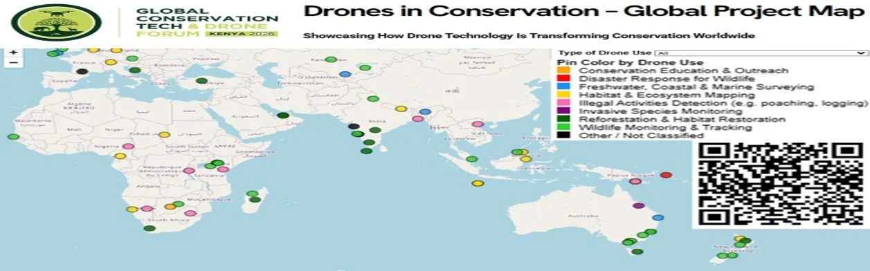
Drone Use-Cases in Conservation – Global Project Map
Showcasing how drone technology is being used for real-world conservation.
Around the world, drones are changing how conservation teams protect wildlife, manage landscapes, respond to threats, and support local communities. The Global Conservation Tech & Drone Forum (GCTDF) is building a practical, community-driven map of active and past conservation drone projects to highlight where innovation is happening, who is leading it, and what impact it is delivering.
This map is an open resource for conservation agencies, NGOs, researchers, drone operators, donors, and technologists who want to learn from field experience and build new partnerships.
This interactive map is best viewed on a desktop or tablet device.
What you can do with this map
Explore drone-based conservation projects across Africa and globally
Identify organisations and teams working on similar challenges
Discover different use cases, platforms, and operational models
See where gaps and opportunities for innovation exist
Submit your own project so others can learn from your work
How to use the map
Click on a project marker to view details such as organisation, location, project purpose, and outcomes.
Zoom in and out to explore regional clusters or national coverage.
Filters by country, use case, and organisation type will be added over time.
The map is updated continuously as new projects are submitted.
Submit your conservation drone project
If you are using drones for conservation, environmental management, community mapping, anti-poaching, restoration, wildlife monitoring, or climate resilience, we invite you to submit your project for inclusion.
Data responsibility
Project information is compiled from public sources and voluntary submissions. While we aim for accuracy, project status may change over time. To request updates or removal, please contact us.
Project Spotlight
“Elephant Monitoring and Anti-Poaching Support, Kenya”
Using long-range fixed-wing drones equipped with thermal sensors, this project supports real-time detection of elephant herds and provides early-warning insights to rangers. Outcomes include reduced human-wildlife conflict and increased patrol efficiency.
Data Responsibility
The information on this map is compiled from public datasets, verified sources and voluntary submissions from project owners. While we aim to ensure accuracy, project status may evolve. To request edits or removal, please contact us directly.